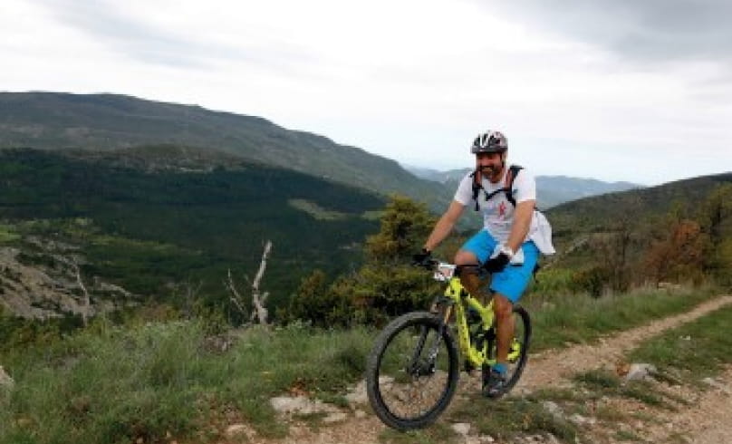
Le Poët
Point 1: Place du Quinconce (km 0 - 371m)
Cross the Ouvèze bridge, turn left and take the first road on the right.
Point 2: Font de Ladon (km 1 - 405m)
Continue straight ahead on the main road for 3.8km.
Junction 3 (km 4.9 - 518m)
Turn right, climb 300m, then left towards La Viste.
Point 4: Bridge over stream (km 8.5 - 656m)
Go straight on for 150m, then turn right. Keep right at the next two intersections towards Pré Laugier.
Point 5: Lake below (km 9.9 - 778m)
Follow the main track to the right, then fork slightly right at the next junction. The track climbs for 3km, then at a crossroads, continue straight on.
Point 6: Col de Geine (km 13.6 - 999m)
Turn left, then left again 70m further on to pass a farm at Les Flaux.
Point 7: Col de la Jas (km 15.8 - 1068m)
Pass the sheepfold and descend to the left, following the GR91.
Point 8: Junction (km 16.9 - 900m)
Turn left, leaving the GR91 behind, to take a small path that joins a track on the right.
Point 9: Ford (km 18.65 - 828m)
Cross the ford and turn left.
Junction 10: D527 (km 18.8 - 790m)
Drive 180m and turn left. Follow the signs: the route alternates between tracks and roads to reach the village of Le Poët-en-Percip.
Point 11: Le Poët-en-Percip, place du tilleul (km 21.4 - 1013m)
Opposite Le Poët-en-Percip, join the GR91. Leave it 150m further along, going straight ahead on a footpath.
Point 12: Crossroads (km 22 - 999m)
Take the left-hand track for 350m. Join another track which you follow to the left.
Point 13: Charbonel (km 23.3 - 1043m)
Turn right and stay on the main track: let the GR91 go right towards the Col des Tunes.
Junction 14 (km 25 - 1031m)
Turn right at the ONF gate, slightly uphill.
Point 15: Col de Sanguinet (km 26.5 - 1080m)
Turn left, then left again 200m further on.
Point 16: La Coste (km 27.8 - 952m)
Turn right, then go straight on for 150m, ignoring the track on the right and continuing westwards.
At the 1st track junction, continue straight on, then 100m further on, ignore the track which rises to the right. Continue for 60m and take the stony path opposite. Difficult descent (km 30.30 - 811m).
Point 17: Château de La-Roche-sur-le-Buis (km 32 - 600m)
The path turns into a track at the Château de La-Roche-sur-le-Buis. Descend to the village and take the tarmac road towards Buis-les-Baronnies.
Point 18: Leaving the village (km 32.3 - 560m)
Leave the asphalt road and turn right through the olive groves onto a footpath.
At the track intersection, fork left and descend to the departmental road. Follow it for 1.1km (km 33 - 535m).
Turn left towards the Menon river, and after 200m, turn right at the flat and cross the footbridge, then turn right. Follow the road to Buis-les-Baronnies.
Point 19: Place du Quinconce (km 36.05 - 371m)
COMMUNITY OF COMMUNES OF THE BARONNIES IN DROME PROVENCALE :
- Circuit FFCT coté rouge (for regular and confirmed cyclists)
- High vertical drop/kilometer ratio
- Trialising sections (presence of steps)
BEFORE SETTING OFF :
- Check the weather forecast before you set off, as the routes may become dangerous in bad weather.
- Find out about the condition of the route before you leave: Buis-les-Baronnies Tourist Office (tel: 04 75 28 04 59)
- Take water, food, a small first-aid kit (double skin, strap and paracetamol), a survival blanket, a windbreaker, a whistle and use brightly-colored, reflective clothing for your safety.
- Whenever possible, don't travel alone: tell someone close to you about your itinerary and planned times, and recharge your phone battery to 100%.
- Be aware of the hunting season (generally from 01/09 to 28/02) and, if possible, inform yourself of the dates and locations of hunting drives.
- For nocturnal outings: avoid routes through grazing areas, and use headlamps suitable for outdoor use.
ON THE ROUTE :
- Respect natural and agricultural environments (no picking, etc.).
- Respect other users of the area (hunters, runners, shepherds, foresters).
- Adopt the right reflexes with guard dogs: stay calm, don't approach the herd and don't interact with the guard dog (go around the area if possible).
- Remember that in the mountains, you are always in the home of someone who accepts you: respecting private property is a guarantee of permanent authorization for passage.
- Close gates after you've passed through, and don't cross fences.
- Stay on marked trails, don't cut laces
- All sections of the trail on public roads are subject to the Highway Code, so please respect it.
- Keep all your garbage with you and leave no trace of your passage.
- No fires in the mountains. If you see a fire or suspicious smoke, call 112.
- AddressPlace du Quinconce
26170 Buis-les-Baronnies - Phone04 75 26 34 37
- Emailcontact@cc-bdp.fr
- WebsiteSee the website
Our tips
- Details about route marking :
Circuit n°4 (noir) - Map references :
TOP 25 IGN 3139 OT
TOP 25 IGN 3140 ET
Drôme Tourisme cannot be held responsible for any problems encountered along the route.
Any problems encountered can be outlined here:
Author: Conseil Départemental de la Drôme - Apidae Tourisme

