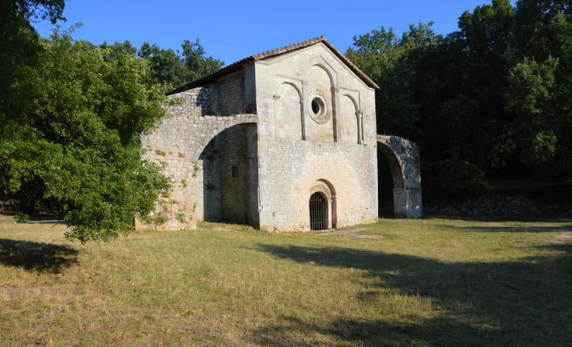
Le secret du Val des Nymphes
From the parking lot, turn right towards the Porte Nord, take the stone staircase, then the gravel path on the left (Chemin de Malpassé) and walk around the ramparts.
Continue along the asphalt road, turning left then right. Arrive at the cross (metal on white stone column), turn right onto the D158 and after 160 m, take the open staircase in the low wall beside the road to the right.
Take the stairs, then the downhill path to the D158. Cross the road (with care), and turn right for 60 m downhill, then take the tarmac path on the left. After 150 m, you'll have a fine view of the village as you turn around. Continue along the track and, at the Y junction, turn left (alongside an old house) along the gravel path for 350 m.
Take the gravel path (formerly a "calade") on the right, which climbs steeply (several paths on the right and left, follow the signs), to the "Montagne du Collet" (171 m).
Take the left-hand path that follows the ridge line, and after about 300 m, observe the stone vats (falsely marked on the map as "sacrificial stones"), the first on the right a little below, and the other 20 m further on: these are grape crushers whose origins could date from the Roman Empire to the early Middle Ages. Several other vats are indicated by wooden signs. Follow the signposted path to the Val des Nymphes parking lot. Turn left onto the D 472, and stop at Val des Nymphes to admire the façade of the listed chapel and permanent springs.
Monument Historique and the permanent springs that feed a large pool. Return to the D 472. In the direction of La Garde Adhémar, about a hundred meters on the right-hand side, on a ledge above the road, you'll find two more vats of
vats. Continue on the D 472 and pass a large building, a former silk spinning mill, now home to a contemporary art gallery. After 200 m, take the well-marked path downhill to the left, past plantations of truffle oaks, then a large field of lavender on the left. The village of La Garde Adhémar comes into view (silhouette). Continue along the path until you reach the small asphalt road on the right, which climbs steeply to reach the village and the parking lot, either by going around the village outside the ramparts, or by crossing the village via the narrow streets.
- AddressDépart Parking nord du village
26700 La Garde-Adhémar - Phone04 75 04 41 3104 75 04 07 98
- Emailcontact@drome-sud-provence.com
Our tips
- Details about route marking :
Balisage PR jaune (promenade et randonnée). Tracé rouge sur la carte. - Difficult stretches :
Montée prononcée jusqu’à la « Montagne du Collet » (171 m). - Map references :
En partie sur le Chemin des Arts en Tricastin. Carte IGN Série Bleue 3039 VALRÉAS.
Possibilité de prendre le circuit 9 (tracé bleu)
Drôme Tourisme cannot be held responsible for any problems encountered along the route.
Any problems encountered can be outlined here:
Author: Conseil Départemental de la Drôme - Apidae Tourisme

